

So magnificent and distinctive does it look during Sunset that I wish I stayed more like one of the readers mentioned on the Facebook group. The sunsets make the north rim glimmer in hues of oranges at the top, while the rest remains black as the sun rays trying to find a way into the Canyon but the Canyon stands
put.
But going blindly by Facebook left us conflicted on which direction to move from after a point. When we googled ‘Black Canyon of the Gunnison’ on the map while driving from Aspen from somewhere in between, we were to make a choice – to head to north rim or the south rim? Oh, how have we forgotten Canyons have rims. And how foolish were we, that we thought we could get by without any research knowing that networks can be missing in some areas. Thankfully, we landed in the right rim easily accessible – the south rim.
How were these Canyons formed?
Over a billion years ago, molten rock was squeezed into fissures forming the light-colored bands which thread Black Canyon’s otherwise dark walls. We were standing on one of these bands. As the hot fluid slowly cooled and hardened, minerals formed into crystals. On looking closely, one may even recognize flecks of Mica, Feldspar, Quartz and even Garnet. Those bands of lighter colored igneous rock – called pegmatite dikes – are more resistant to erosion than the dark gneisses(sounds like “nice-es”) into which they intrude.
Consequently, the pegmatite weathers more slowly than the gneiss. The vertical position of the dikes here, combined with their resistance to weathering, has produced the fin-like appearance of parts of the canyon walls. You will see pegmatite at nearly every overlook.
Swift water of the Gunnison river and abrasion from the sediment it carries are the chief cutting tools in the deepening of the Black Canyon but there are other forces important to the carving of the canyons. Moisture entering joins and fractures promote weathering.
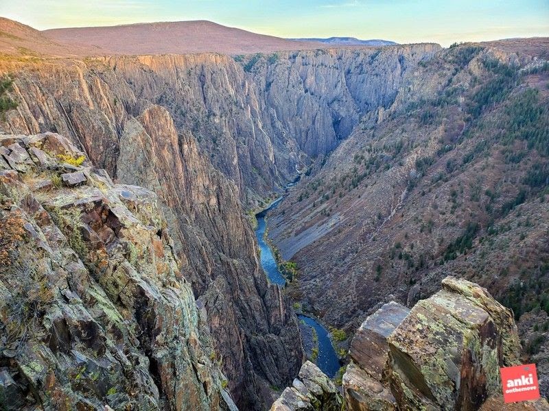
The South Rim Drive is 7 miles from Tomichi Point to High Point, and has 12 overlooks.The South Rim Visitor Center, which features exhibits on the canyon, is located at Gunnison Point. As we drove from Gunnison Point to the High Point, we found ourself driving parallel to the canyon. This short drive is a beautiful drive.
As we reached the High Point, we found ourselves staring at 180 degree vista of the Canyon. To our right was the south rim. The south rim has eroded back farther than the north (to our left). The south rim faces north so it does not receive as much sun and does not dry out as quickly as the north rim. Since moisture is an important factor in erosion, a moist slope will tend to erode at a faster rate than a dry slope.
Thus, the canyon rims are gradually worn away. What the river can’t carry away accumulates as steel piles of talus against the canyon walls or creates rapids in the river.
The carving process has been slowed by the construction of the dams upstream. These dams hold back most of the sediment and most of the peak spring runoff, both of which are necessary for the river to deepen its bed effectively and carry off material eroded from the canyon walls.


The Canyons at the North Rim are steeper and hence fewer lights get in. That is also where, the road is less paved, and it’s more primitive from what I have heard. South rim whereas, where we went, has paved roads, a visitor center, and a couple of vista points.
Our first stop was Tomichi Point. Tomichi Point gives us the first glance into the canyon. As we drove further we reached the South Rim Visitor Center. Gunnison Point is behind the South Rim Visitor Center. During our visit, it was already 6 pm, the Visitor Center was closed but the trail from the back was open. These are just a few stairs onto the vista point that gives you a panoramic view of the Canyon. A scenic drive to the High Point takes you to a few more vista points and these are even more beautiful.
Here is a quick photo essay from the canyon:

On the way from Aspen to Ouray via Black Canyon…


Drive to Ouray.