
 in Vanur
taluk. The ravine, a narrow, deep valley with steep sides, has an average height of 7 metres, a width of 30 metres.")
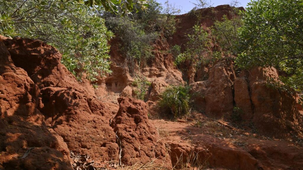
Born out of erosion: The Bommayapalayam
Canyon is known in local parlance as ‘Semmanodai’ (a red rivulet) in Vanur
taluk. The ravine, a narrow, deep valley with steep sides, has an average height of 7 metres, a width of 30 metres.
| Photo Credit: S.S. KUMAR
As nature changes the colour palette, the landscape transforms from interspersed green to a swathe of mahogany, soon after the left turn at Bommayapalayam, eight kilometres on the East Coast Road from Puducherry to Chennai. A sloped dirt road gives way to brownish-red escarpments of the Bommayapalayam Canyon, known in local parlance as “Semmanodai” (a red rivulet) in Vanur taluk of Villupuram district. Beyond the last couple of dwellings at this site lies an uneven and rugged terrain that alternates between patches of vegetation and barren earth, escarpments and narrow gullies.
The canyon is part of a range of ravines skirting the Auroville bio-region. These ravines were formed over centuries of downcutting by water currents of the monsoon rain ferrying topsoil and rock fragments to the Bay of Bengal. The Tamil Nadu government recently announced a plan to protect the canyon, believed to be a repository of geological data dating back by centuries, declaring the ravine formation with reddish earth as a geo-heritage site.
Improving understanding
The plan is also aimed at enhancing the understanding of dynamic geological processes among students and scientists. According to officials at the Villupuram Collectorate, the proposal, first floated in May 2022 by the then Collector to the Commissioner of Geology and Mining, recommended protection and maintenance of the ravine formation. The ravine, a narrow, deep valley with steep sides, has an average height of 7 metres, a width of 30 metres. It dates back to the Miocene age estimated to be in the range of 23.03 to 5.33 million years ago.
A preliminary inspection was conducted by a team led by the Regional Joint Director of Geology and Mining. “A detailed proposal will be submitted to the government through the Commissioner of Geology and Mining in Chennai,” said an official. The Public Works Department will be the implementing agency.
“The canyons are the cumulative outcome of years of soil erosion, rather than any tectonic activity,” said Deepika Kundaji, national award-winning farmer-soil conservationist and seed-saver at Auroville. Unlike the appearance of a geological formation or a denuded hillock, the canyon is sculpted out of eroded land. It is important from a geological perspective, because the ridges formed from long periods of soil erosion can reveal terrestrial truths. Analysis of the strata on the ridges or fossils of the now-extinct plant species can unearth important geological information, said Ms. Kundaji, a recipient of the 2017 Nari Shakti Puraskar.
When it was created in 1968, Auroville inherited a barren plateau about 50 metres above the mean sea level that stood as a testament to rapacious deforestation at least since the 1700s. The region, with the presence of limestone, bauxite, and iron ore, was vulnerable to rapid top soil erosion and further biodiversity loss, given the proximity to a range of canyons. From the early days, Auroville planners, especially its conservation experts, have mapped and studied the topography of the bio-region. All rainwater from the plateau makes it to the Bay of Bengal, only running down different routes from the three main watersheds in the Auroville region — the Pitchandikulam-Bommayapalayam area that slopes directly towards the sea, the Irumbai lake-Kazhuveli tank, and the Ousteri lake lying to the west.
Measures to check erosion
Over the years, collective action resulted in a raft of counter-erosion measures, ranging from mission-mode tree planting to building checkdams and bunds to arrest the flow of water and facilitate soil regeneration. “The erosion of topsoil down the slope has declined,” said Arul, whose family has been living near the ravines for over four decades. The water drawn from hand-pumps is potable and soil is fertile to grow fruits such as mangoes, jack-fruits, and water apples that are more succulent, he said. “There was a time not too long ago when the canyon served as a picnic spot, a hiking trail, and even as a movie set for action scenes or song sequences. However, there are fewer visitors these days,” he said. If anything could be worse than abandoning a geology-rich site to the ravages of nature, it is to allow unregulated entry by picnickers who leave behind garbage; at a few places are glass shards from beer bottles shattered by the unruly sorts. “It is imperative that canyon sites are protected and regenerated to offer more of an educational, and less of a recreational, experience,” said Ms. Kundaji.
Canyons are often likened to silent journals of a land’s evolution over long periods. Though triggered by natural causes, the cliff-like formations arising from the earth are also emblematic of man-made and long-term environmental destruction.
Turbulent past
The Bommayapalayam Canyon sits on a landform that has been witness to a turbulent past: of warring kings, the overlapping influence of Anglo-French imperialism; and reckless plunder of natural resources that wrought long-term environmental cost. Writing in the August 2023 issue of Auroville Today, Ms. Kundaji makes a connection between the political history of the region and the ecological devastation over centuries. According to the Gazetteer of Pondicherry, in 1703 “Francois Martin who acquired Kalapet village, then famous for its timber, from Nawab Dawood Khan is reported to have used the wood from its forest for building houses in the town newly founded by him. The origin of ravines in Kalapet may perhaps be attributed to this process of depletion.”
Ms. Kundalji reckons that soil erosion resulting in canyon formation is the most extreme and irreversible form of land degradation. “Canyons should serve as a reminder of the types of soil deposits lost to erosion over millenia”.
Published – April 10, 2025 10:23 pm IST
Source:https://www.thehindu.com/news/national/tamil-nadu/a-miocene-age-canyon-in-villupuram-is-a-repository-of-centuries-of-geological-data/article69434714.ece