
In the last decade or so, the remote and godforsaken easternmost extremities of Arunachal such as Walong, Dong, Kibithu, and Kaho have suddenly achieved fame. Walong, situated in the Anjaw district, found itself in thick of action during the 1962 Sino-Indian War. Interestingly, during that era, motorable roads did not even exist on the Indian side and it used to take days to get to these places from the plains. Nevertheless, the recent trend of tourism in these areas has been made possible by significant infrastructure development by the government.
In fact, several names have come up during this period as the “easternmost” place in India, the one that receives the first rays of the sun in a day. Most of these villages like Kaho, Kibithu and Dong, are located at similar latitudes while, the hike above Dong Valley takes one to a point that offers a great viewpoit to catch the first sunrise. Some even do on on the new year’s eve to catch the first sunrise of the new year.
So, here’s another thing that I wanted to keep doing ages ago but already became too popular even before I managed to do it. Anyway, just for the record I had to get this done. Anyway, after attending Poi Pee Mau Tai, we drove to Tezu and spenta night there. I idea was to cut the distance for the next day as it was going to be a long drive anyway.
We started at around 7 AM next morning and quickly drove through a somewhat desolated and hilly portion to cross Hawa Camp and Hayuliang as the Lohit reappeared on our right. We did stop at times to clock mudpuddling butterflies at times. Especially a big Paris peacock was the best capture for me.

We kept driving to eventually reach the roadhead with the bifurcation to Hawai. However, we didn’t bother to stop there and moved on as we were getting late.
The Lohit kept us company but it was almost dark when we reached Wallong. The driver was suggesting us to get a room in the circuit house but we wanted to start the hike at 2 AM and so, it was necessary to stay as near as the hiking point. Soon, we figured out that there is a new campsite at a strategic location in Tilam.

So, we drove another 20 minutes and reached Tilam, where there was also a more expensive looking resort but after crossing that, we found a flight of stars going down towards the riverbank. We finally realised that this is the famous hot water spring of Tilam but the campsite also has been developed near it. Anyway, we got our tents and also got dinner for the night.
The alarm was set at 1.30 am but I was awake already. I was expecting this part to be uncomfortable but to be fair, it was not as cold as I’d expected. We came out of our tents, hiked up to the road hoping to meet our guide (as told by the Campsite Lady). We couldn’t see any other hiker too except two of us and another guy from Roing who was staying at the same campsite and whom we managed to convince to try the trek.

Anyway, at around 1.50 am, someone arrived out of the blue and out of the bushes behind us. We asked him if he’s the guide. He said that he isn’t but he will take us to the guide. It was pitch dark and we had no clue what’s happening. So, we started following him. After a while, we reached a river and walked over a hanging bridge which was shivering more than us in the cold. After the bridge we walked through an open area for a few minutes and then suddenly reached a motorable road. So, the actual starting point of the trek was somewhere on the road and this little pre-hike took us to that point from our campsite.
Our guide finally arrived on a bike and asked us to keep walking towards a point (a faint light was visible). He went looking for other hikers who were apparently coming from other locations. I’d actually forgotten to bring by torch and my phone torch had stopped working a few months ago. I was beginning to think that I had made a big mistake but I just tried hopelessly and to my delight, the phone torch started working! (I still think it was a miracle because now it’s stopped working again as I’d reached home).

Anyway… I kept walking and even clicked subpar photographs till we reached a point where a few others were waiting too. This was the actual starting point of the trek and so far we’d only done warm up!
We paid an entry fee of INR 500 per head at that point. Several other trekkers had also arrived by that time. Some were staying at the same place as we were while there were some who drove from Kaho at 1 am to get to this point on time.
Anyway, the trek finally started. The first few minutes were quick as clear steps had been built. After that people got scattered. I had been inactive of late and so, I took breather as some people went ahead. However, there were many others who were coming behind me too.
After slightly more than an hour, I hiked past the last of the stairs to reach a flat open area. There was still a hill ahead of me and one of the guides who’d caught up with me, asked me to keep walking.
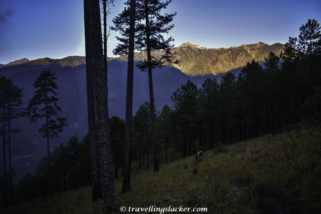
So, I walked through the open grassland to reach the hill that was lined with the famed pine forests (most of the images of Dong available online feature these). It was still dark though and after some easy walk, the hike started again.
Anyway, the end of the trek was near. I could sense it. I’d been hiking for 2 hrs and now I could hear the voices of people who’d already reached ahead of me. After one final turn I saw them above me. One of the guides had lit a bonfire too. This 1 am start had made me forget everything but the bonfire made me crave for tea although it wasn’t going to be possible.

It was around 4.15 am when I reached and the wait started. There was a faint light on the east but soon I realised that the real sunrise will take much more time and the primary view will be on the western hills illuminated by the first rays of the day.
We waited white chatting with other people who’d arrived from various places. The bonfire came handy as it was pretty cold.
All the while I was waiting for the moment when I’ll go offline to finally have my momentarily digital detox. However, Inrealsied that a few months ago the towers were finally established and now, the entire area including this hilltop where nobody lives also has full connectivity. I was disappointed but this helped me to search for and download an app to show elevation. At the highest point, the altitude showed to be 1807 meter. I knew that Song village was somewhere near 1200 meters. So, we’d gained an elevation of almost 600 meters during this quick hike.
Anyway, it was taking more time than I’d expected. Finally, at around 5.40 am, it began to get brighter and suddenly the dark hill behind us turned marmalade.

Everyone got busy clicking photographs and finally the famed pine forest under us became visible too. This stretch now somewhat reminded me of Emuli Grasslands on the first day of Anini Seven Lakes Trek.

We spent around an hour clicking pictures till it got too bright to ruin the the hues and so, we started hiking down. Walking past the grassland offered us much better landscapes now.

After a while we crossed the grassland stretch and reached the stairs that we’d crossed at night. I was actually quite surprised by the view of these stairs in broad daylight.At night we just pushed ourselves in the dark but now, looking at the serpentine trail without any sight of the end, I retrospectively patted myself on the back.


We were back to the starting point in less than two hours and it was barely 8 AM. Finally, I also could enjoy the view of the hanging bridge over the teal blue Lohit River that we’d crossed earlier at night.


Back at the campsite we had a quick breakfast. It was the time to leave but there was something else remaining, the hotwater spring bath. Actually, Tilam is famous for its hotwater spring and the campsite has now come up at the same site. They have built enclosures for privacy and one can take the keys from the campsite for a small fee. It is a relaxing activity after the hike that reminded me of the Hot Stone Bath at Paro after the Tiger’s Nest Trek.

I also shot some videos and made an attempt to create a viral video (and failed as expected). Anyway, you can watch them below.
Dong Travel Guide
How to Reach Dong Valley?
If you are taking public vehicles (shared vehicles) from Tezu, they will take the whole day and eventually leave you at Wallong. You will have to find something there to get you to the campsite at a place called Tilam or trek starting point. It is much easier (but much more expensive) if you hire a vehicle for yourself. This is why, although it is not my usual style, I joined with some people and hired a vehicle for the trip to directly reach Tilam and stay there.
How Long is the Hike?
It is around 5 KMs and takes around 2 hours (+/-20 minutes depending on your speed). Return will also take another 1.5-2 Hrs.
What is the maximum elevation of Dong Hike?
I found it out to be 1807 meters. Th le campsite below is close to 1200 meters. So, the hike involves an altitude gain of around 600 meters.

Where to stay for the Dong Hike?
There are multiple options…

Campsite at Tilam (near the hotspring), on the bank of the river, is where we stayed. You have to hike down the stairs to reach this place. We paid INR 700 per head for individual tents. They also provide food for extra charge and charging points and other facilities. You will see the gate in the picture below, through which you will go down to reach the camp. This is the option I suggest.

The same area also has a resort located nearer to the road which is more expensive.
The main Dong village apparently has some facilities but we never reached that part.
Can one stay in Walong or Kaho for the hike?
The area ahead, including Namti and Kaho has homestays. However, as I have mentioned before, if you intend to do the sunrise hike, you will have to start at midnight. Similarly, Walong, around 10 KMs before Tilam, has a Circuit House and some other options.
Is there phone and internet connectivity at Dong?
Unfortunately yes! A few months ago connectivity was established. Now cringe live dance reels can also be made at the top!
Are guides necessary? How much do they cost? Where to find the guides.
Technically not but there are rules and guides are now compulsory! The INR 500 entry fee accounts for the guide fee. (They usually wait near the entry point and wait for enough people to gather before starting).
If you are unlucky and there is no one else to share, they may charge higher.
Usually, you don’t have to go searching fo rthe guides. Just reach the entry point and they will be there. (Ask people at the campsite for guidance)
Is it necessary to start at midnight?
The whole point of starting at midnight is to reach before sunrise. This is actually a symbolic activity as these are the easternmost areas of India. So, you are catching the first rays of sun to fall on India by doing this. However, you can visit at other times too. If you need .ore time, you can go in the afternoon, camp near the top, and wait for the sunrise.
Solo traveller since 2010
#Himalayas & #Northeast
Cinephile, Misanthrope, Anti-selfie
Atlas Obscura/Mint/Discover India